Trail Walking La Bretonnière-la-Claye - Boucle del'ile de la Bretonnière- La Claye - Photo

Boucle del'ile de la Bretonnière- La Claye

 tupeutla
tupeutla

User

© OpenStreetMap contributors
Length
Length
13.1 km
Max alt
Max alt
31 m
Uphill gradient
Uphill gradient
92 m
Km-Effort
Km-Effort  
14.3 km
Min alt
Min alt
0 m
Downhill gradient
Downhill gradient
91 m
Boucle
Boucle
Yes
Creation date :
2015-11-07 00:00:00.0
Updated on :
2015-11-07 00:00:00.0

(0 Reviews)

Walking
Walking
3h11
Difficulty : Easy

Scan this QR Code to open this trail in the SityTrail application

FREE GPS app for hiking

Logo SityTrail SityTrail

IGN / Geographical institutes

Download SityTrail from the App Store Download SityTrail from Google Play

Logo SityTrail SityTrail World

The world is yours!

Download SityTrail from the App Store Download SityTrail from Google Play Download SityTrail on Huawei AppGallery

About

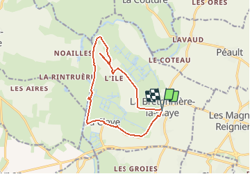
Trail Walking of 13.1 km to be discovered at Pays de la Loire, Vendée, La Bretonnière-la-Claye. This trail is proposed by tupeutla.

Description

Ce parcours fait le tour d'une ancienne ile entourée de marais et bordée par le Lay.

Elevation profile

Positioning

Country:
France
Region :
Pays de la Loire
Department/Province :
Vendée
Municipality :
La Bretonnière-la-Claye
Location:
Unknown
Start:(UTM)
633916 ; 5149146 (30T) N.

Trails nearby

Trail Walking La Bretonnière-la-Claye - Mortevielle  - Photo
Walking
hoquet

Walking

La Bretonnière-la-Claye, Pays de la Loire, Vendée, France
7.6 km | 8.2 km-effort
1h 39min
Yes
Trail On foot La Bretonnière-la-Claye - S10-La Claye 8,5 - Photo
On foot
gegedo

On foot

Easy
La Bretonnière-la-Claye, Pays de la Loire, Vendée, France
8.8 km | 9.7 km-effort
2h 12min
Yes
Trail Walking La Bretonnière-la-Claye - La Claye - Photo
Walking
sr230578

Walking

Easy
La Bretonnière-la-Claye, Pays de la Loire, Vendée, France
8.1 km | 8.8 km-effort
2h 21min
Yes


Close
My subscriptions